The SMN warns of storms this Wednesday and a change in temperature in the AMBA.
Agregar La Derecha Diario en
Compartir:
The weather in the AMBA changes markedly this Wednesday, April 1, with storms, heat and the advance of a cold front.
According to the National Weather Service (SMN), an unstable day is expected with rain and a temperature that is still high before the descent.
The weather in the AMBA changes markedly this Wednesday, April 1
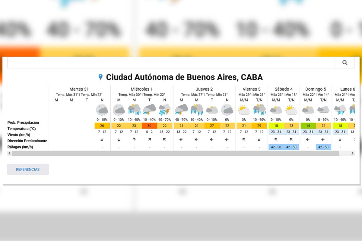
What will the weather be like today in the AMBA
According to data from the SMN, this Wednesday has varying conditions throughout the
day.
Minimum: 22°C
Maximum: 30°C
Probability of rain: between 10% and 70%
During the morning the sky remains mostly cloudy, while towards the afternoon and night the chances of storms increase
.
When do the strongest storms arrive
The most unstable time is expected between the afternoon and evening of Wednesday
. When do the strongest storms arrive
During this period, showers, isolated storms and gusts may occur. The SMN report warns that some rainfall could be intense in
short periods.
The heat follows before the temperature change Before
the cold air enters, the environment is kept warm and humid. This phenomenon responds to the presence of tropical air that increased wind chill in recent days
. The heat continues before the temperature change
The combination of heat and humidity creates heavy days and ideal conditions for storms
.
What is happening with the rains in the region
In the last few hours, different areas of the country recorded heavy rainfall. There were significant accumulations in the province of Buenos Aires
.
In some sectors, 100 mm was exceeded in a few hours.
What happens with the rains in the region
What is the weather like in Buenos Aires
On Thursday, instability will continue, with a chance of rain for much of the day.
Temperatures will remain high, with highs close to 27°C.
However, towards the weekend, a more marked change begins.
What's the weather like in Buenos Aires
Decrease in temperature and autumnal weather The onset of the
cold front is consolidated between Saturday and Sunday.
The highs fall progressively to around 22°C on Saturday and 21°C on Sunday.
In addition, the environment becomes drier and less heavy, typical of autumn in the AMBA.
Recommendations for storms and gusts
The SMN recommends following official reports for possible strong
storms. Extended Forecast - SMN
It is also suggested to avoid driving in flooded areas and to secure
objects that can be flown.
The weather change will be abrupt, so you should be aware of the evolution of the weather over the next few hours.