The SMN forecasts isolated rains on Saturday and a significant drop in temperature on Sunday.
Nuevo
Agregar La Derecha Diario en
Compartir:
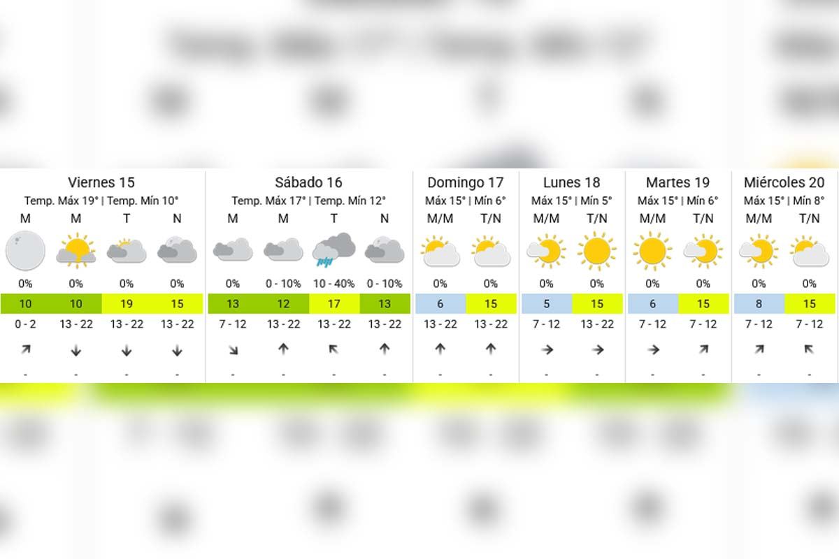
The weather in the AMBA is closing the week with cold mornings, milder afternoons, and a weekend marked by the possible return of instability. According to the National Meteorological Service (SMN), this Friday, May 15 starts with clear skies, a cool atmosphere, and temperatures around 10°C.
After several days dominated by cold and dry air, conditions are beginning to show some changes. Although no strong storms are expected, Saturday could bring cloudiness, isolated drizzles, and a new temperature drop towards Sunday.
The AMBA is experiencing a week closure with cold mornings.
How the weather will be this Friday, May 15 in the AMBA
Friday appears to be the most pleasant day of the week in the City of Buenos Aires and the Greater Buenos Aires area.
According to the SMN, the day will have a minimum of 10°C and a maximum reaching 19°C, with skies ranging from clear to partly cloudy for most of the day.
The north wind will help boost a thermal recovery during the afternoon, creating a much milder autumn atmosphere than in previous days.
Friday appears to be the most pleasant day of the week.
Additionally, there is no chance of rain for this Friday, and conditions will remain stable until nightfall.
Instability returns to the AMBA on Saturday
The most significant change will arrive on Saturday, May 16. The updated forecast from the National Meteorological Service shows a marked increase in cloudiness and chances of isolated precipitation.
On Saturday, instability returns to the AMBA.
The early morning and morning will start mostly cloudy, with temperatures between 12°C and 17°C.
During the afternoon, there is a probability of rain and drizzles ranging from 10% to 40%, especially over areas of the conurbation and regions near the Río de la Plata.
For now, no intense storms or severe phenomena are expected, although the atmosphere will feel considerably more humid and unstable than in previous days.
In the afternoon, there is a chance of rain.
Temperature drops significantly on Sunday
After the arrival of colder air on Saturday night, Sunday will bring back the typically winter atmosphere.
The SMN predicts a minimum close to 6°C and a maximum of just 15°C, with south winds and a low thermal sensation for most of the day.
On Sunday, the temperature drops significantly.
The good news is that the sun will gradually reappear from the afternoon, and no rain is expected to close out the weekend.
How the weather will continue next week
The trend indicates that the cold will remain in the metropolitan area for several more days. Between Monday and Wednesday, minimums are expected to be between 5°C and 8°C, while maximums will hover around 15°C.
The sky will remain mostly clear, and at least for now, the SMN does not anticipate new significant rains for the AMBA.
Extended forecast - SMN
What will happen on the Atlantic Coast
Meanwhile, the Atlantic Coast will continue to show more unstable conditions than the Capital and the conurbation.
Locations like Mar del Plata could maintain cloudiness, wind, and some light precipitation during Saturday, with temperatures significantly lower than those recorded in the AMBA.