The SMN anticipates colder days, without rain and with lows of up to 8 °C in the AMBA.
Nuevo
Agregar La Derecha Diario en
Compartir:
The National Weather Service (SMN) confirmed that the cold front in the AMBA has already been installed and will mark the weather conditions for the next few days, with temperatures dropping and without rain.
This Thursday, April 30, began with a stable scenario in the City of Buenos Aires, but with colder air in circulation that will intensify towards the weekend.
The SMN confirmed that the cold front in the AMBA has already been installed
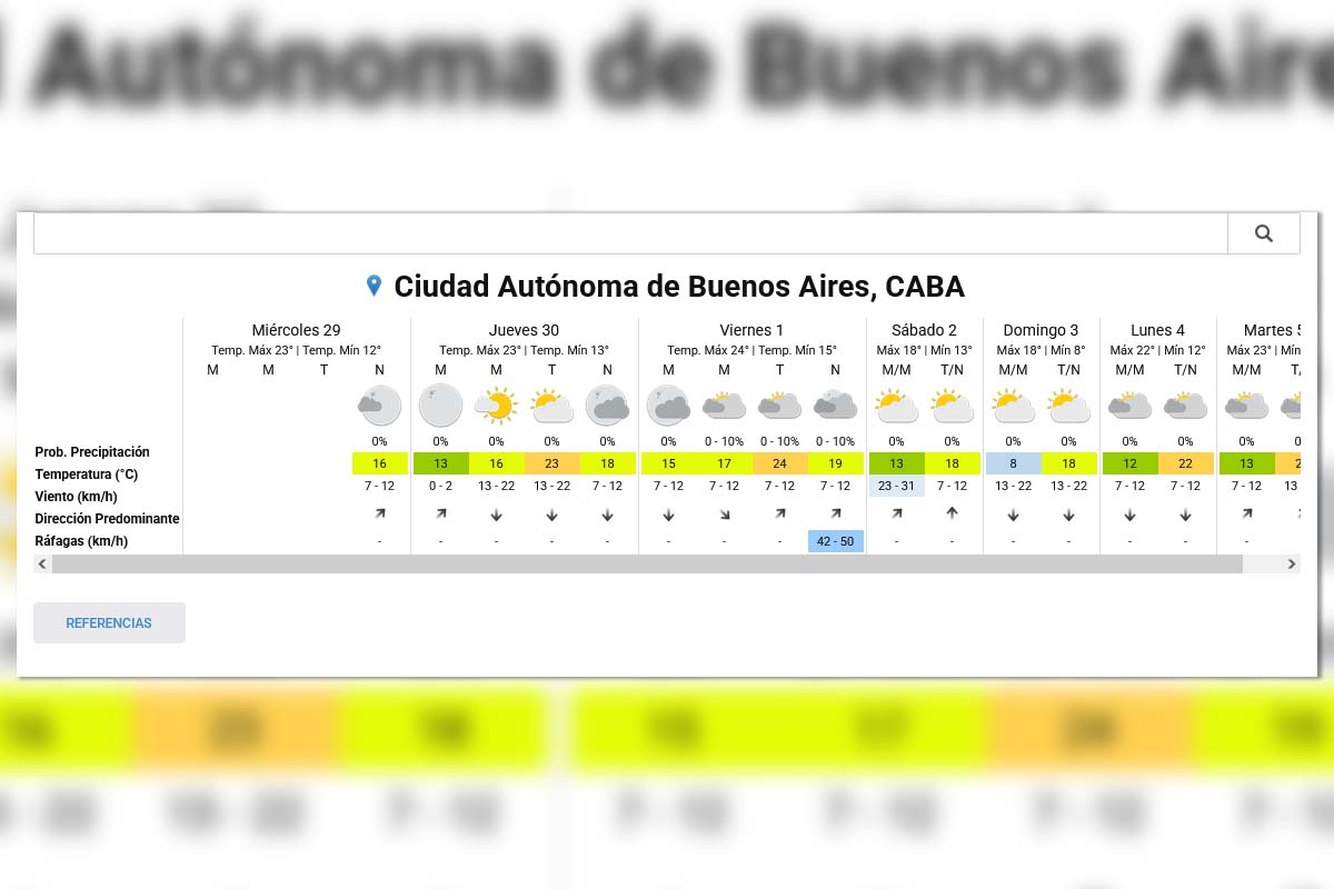
What is the weather like today, Thursday, April 30 at the AMBA
According to the SMN, this Thursday has partly cloudy skies during the day,
with dry conditions.
The temperatures are between 13 °C minimum and 23 °C maximum, with light to moderate wind and no chance of precipitation.
Friday, May 1: more cloud cover and a slight drop in temperature
For Friday, the body expects a greater presence of cloud cover, with a mostly covered day
. Friday, May 1: more cloud cover and a slight drop in temperature The temperature will range between 15°C and 24°C, while the chance of rain remains low, between 0% and 10%.
Wind gusts that could reach between 42 and 50 km/h are expected
.
Long weekend: thermal drop and no rain The inflow
of cold air will be consolidated from Saturday, with a clear change in thermal conditions
.
Saturday, May 2: low of 13 °C and maximum of 18 °C
Sunday, May 3: low of 8 °C and maximum of 18 °C
Long weekend: temperature drop and no rain
Sunday will be the coldest day, with the lowest minimum temperature of the period. No precipitation is expected during both days, with partly cloudy skies and
a dry environment.
Start of next week: mild temperature spike
Monday, May 4, will show moderate thermal recovery, with values between 12 °C and 22 °C, according to the SMN forecast
.
The weather will remain stable, with no rain and with variable cloud cover.
Extended Forecast - SMN
What explains the change in climate in Buenos Aires
The SMN attributes this scenario to the advance of a mass of cold air that moved over the region and
consolidated drier conditions.
This pattern reduces the likelihood of rain and generates thermal amplitude, with cooler mornings and milder afternoons.