The weather this Tuesday, July 28 starts with 12°C in the AMBA, in a day that continues with the thermal mildness of recent days, although it is beginning to give way to the return of cold air. According to the National Meteorological Service (SMN), the maximum will reach 16°C, with no chance of precipitation.
The week shows a progressive thermal drop towards Thursday, with a rise in temperatures and the arrival of rain and storms towards the weekend.
The week shows a progressive temperature drop towards Thursday
Weather for today, Tuesday, July 28: cold wind returns
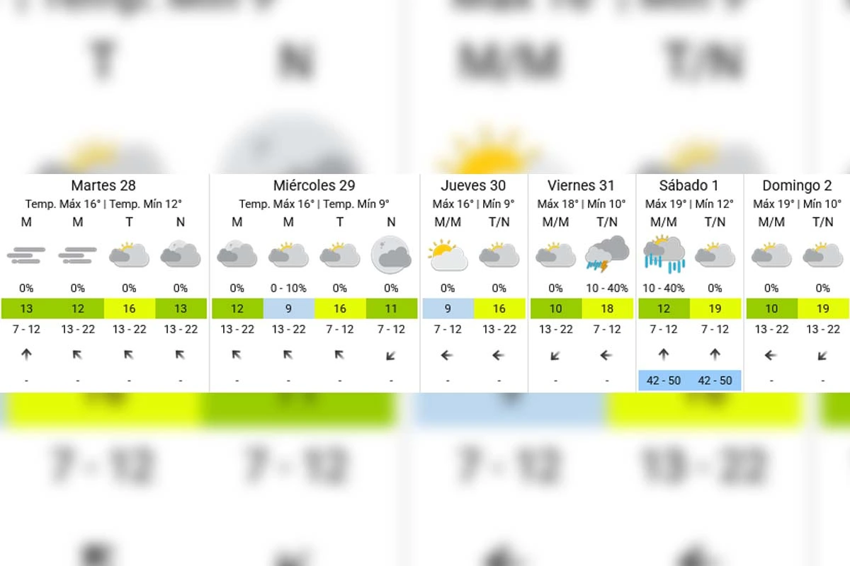
This Tuesday, the wind vane turns and the thermometer begins to leave the spring-like temperatures of previous days. The morning shows mostly cloudy skies and a light south wind, with a minimum of 12°C.
The day will pass with little sun and circulation of cold air, so the thermometer will reach a maximum of 16°C in a gray and somewhat windy afternoon. Towards the evening, a cold front will re-enter with intensified winds, closing with 13°C.
Weather for tomorrow, Wednesday, July 29: cold morning, pleasant afternoon
The Wednesday will continue with thermal attenuation, maintaining the cold wind and limited sunshine. The SMN forecasts a minimum of 9°C, with mostly cloudy skies during the morning.
Weather for tomorrow, Wednesday, July 29: cold morning, pleasant afternoon
The day will maintain the circulation of cold air throughout, with a maximum of 16°C in a gray and windy afternoon, with no chance of rain.
Weather for Thursday, July 30: wintry dawn
The Thursday promises a sunny morning, although with a more marked drop in the minimum. We will return to winter-like records with 9°C at dawn, according to the SMN.
Weather for Thursday, July 30: winter dawn
It will be the day with the least cloud cover of the week, allowing the mercury to recover to a maximum of 16°C during the afternoon, with no chance of precipitation.
Weather for Friday, July 31: storms arrive
The Friday will be a day of constant atmospheric monitoring, with a minimum of 10°C and a chance of precipitation between 10% and 40%, according to the SMN.
The warm and humid air mass will push the maximum to 18°C, pulling us out of the winter segment again, although with the first wave of storms associated with that mild circulation.
Weather for Friday, July 31: storms are coming
Weather for the weekend: Saturday, August 1 and Sunday, August 2
The Saturday will bring the most unstable day, with rains and storms that could leave accumulations between 42 and 50 millimeters, according to the SMN. The minimum will be 12°C and the maximum will be 19°C, with a chance of precipitation between 10% and 40%.
The Sunday will show an improvement, with a minimum of 10°C and a maximum of 19°C, with no significant chance of rain.
Extended forecast - SMN
How temperatures will continue during the week
We start the week with a thermal kindness that is already beginning to say goodbye: cold air will start circulating again from noon today and temperatures will return to more typical winter values by Wednesday and Thursday.
What is clear is that we have left extreme cold behind, although the thermometer and the calendar will sync up again in the coming days, before a weekend with rains and storms that will mark the end of July.